Showing 27 items matching 'kennington'
-
 Bendigo Art Gallery
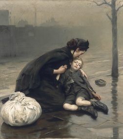
Painting, Thomas Benjamin Kennington, Homeless, 1890
Signed and dated, l.r., brown oil "T.B. Kennington. 1890" -
 Bendigo Military Museum
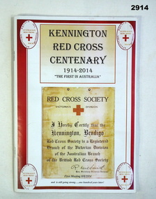
Book - BOOK, RED CROSS, Bendigo Uniting Care Print Shop, Kennington Red Cross Centenary 1914-2014, Pos 2014
Book, soft cover, red border on white background with title & photo of Society's Registration Certificate on front. Welcome back poster with red border on back cover. 48 cut edged pages. Illustration in colour & black & white, complete history of unit with member's details & events from Inaugural Certificate to 2014.books - medical, essential services-red cross, kennington -
 Bendigo Military Museum
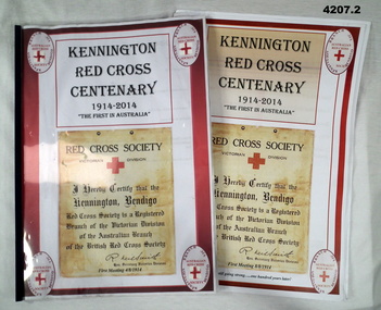
Booklet - FACSIMILE BOOKLETS, Bendigo Uniting Care Print Shop, Kennington Red Cross Centenary 1914-2014, 2014
Facsimile booklets are a proof printing, as well as written correction fluid has also been used..1) & .2) Cover, clear plastic with threaded binding over the title page, red boarder on white background, black print on front with coloured photo of the Societies registration certificate on the front. In colour on the back “Welcome Back” poster with yellow border, 47 pages, white pages, illustrated in colour and B & W , complete history of the unit, members and events from inaugural certificate to 2014. .1) Handwritten in blue, black and red ink numerous corrections throughout.red cross, kennington sub branch, 100 years -
 Bendigo Military Museum
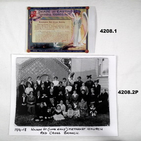
Memorabilia - CERTIFCATES, PHOTOGRAPH RED CROSS, 3) 2014
.1) This certificate was presented to individual members of the Kennington Sub Branch of the Red Cross..1) Colour photo of a certificate titled “After the Great War of 1914 - 19” presented to “Kennington Red Cross Society” members. Illustrated with an angel, flag and dove and record of work done by the branch listed. .2) Copy of a photograph B & W of a group of Red Cross members in front of a weatherboard building with hand written information. .3) Laminated copy of a certificate , Black and red print, illustrated sepia poster..1) Hand written in black ink, “Mrs V.Smith, J Lansell, A Montgomerie”. .2) Hand written in black ink, “1914 - 18 Wilson St (Long Gully) Methodist Church/Red Cross Branch”. .3) Handwritten, “Kennington Branch” and signed by President and CEO of Australian Red Cross.red cross, kennington sub branch, 100 years -
 Geelong Gallery
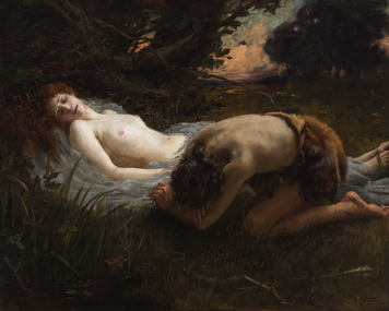
Painting - Cephalus and Procris, KENNINGTON, Thomas, 1897
Oil on canvas -
 Uniting Church Archives - Synod of Victoria
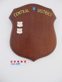
Award - Wooden Shield
Methodist Order of Knights Central District Shield. Dark stained wood with gilt text and MOK enamel badge. There are two small chrome shields on the front and brown paper on the back."CENTRAL DISTRICT" "1963 Castlemaine" "1964 Kennington"methodist order of knights -
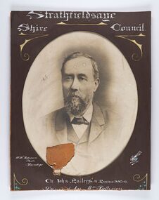 City of Greater Bendigo - Civic Collection
Photograph - Portrait of Councillor Patterson, W H Robinson
The district of Strathfieldsaye was proclaimed in 1861 and named a Shire on the 17th September in 1866. It remained a shire until amalgamation in 1994 when it became part of the City of Greater Bendigo. The shire was located 8 km to the south- east of Bendigo and covered an area of 601 square kilometres and extended from the Calder Highway to the Coliban and Campaspe Rivers. The shire's administration centre was in Strathfieldsaye until 1972 when new offices were opened in Kennington. Framed black and white head and shoulder portrait of Councillor Patterson with hand coloured and drawn detail. Profile slightly to left, face is bearded. Cut oval brown mount decorated with text and flowers. Hand written title top and lower centre.Strathfieldsaye / Shire Council / W. H. Robinson / Photo / Bendigo J N B Gribble / Cr John Patterson President 1885 -6 / Presented by Mrs Pattersonstrathfieldsaye shire council, councillor patterson, president of strathfieldsaye shire -
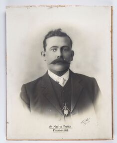 City of Greater Bendigo - Civic Collection
Photograph - Portrait of Councillor Burns, Vincent Kelly
The district of Strathfieldsaye was proclaimed in 1861 and named a Shire on the 17th September in 1866. It remained a shire until amalgamation in 1994 when it became part of the City of Greater Bendigo. The shire was located 8 km to the south- east of Bendigo and covered an area of 601 square kilometres and extended from the Calder Highway to the Coliban and Campaspe Rivers. The shire's administration centre was in Strathfieldsaye until 1972 when new offices were opened in Kennington.Framed black and white head and shoulder portrait of Councillor Burns with hand coloured and drawn detail. Front profile with walrus moustache, image encircled. No mount. Hand written title lower centre. Cr Martin Burns / President 1914 / Vincent Kelly / Bendigostrathfieldsaye shire council, councillor burns, president of strathfieldsaye shire -
 City of Greater Bendigo - Civic Collection
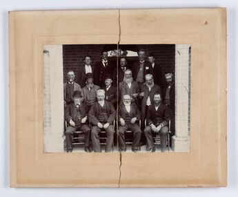
Photograph - Councillor group portrait, D.G. Coope & Son - Framers
The district of Strathfieldsaye was proclaimed in 1861 and named a Shire on the 17th September in 1866. It remained a shire until amalgamation in 1994 when it became part of the City of Greater Bendigo. The shire was located 8 km to the south- east of Bendigo and covered an area of 601 square kilometres and extended from the Calder Highway to the Coliban and Campaspe Rivers. The shire's administration centre was in Strathfieldsaye until 1972 when new offices were opened in Kennington.Framed photographic group portrait of fifteen men taken in the alcove of the Strathfieldsaye Shrie Hall. Four men are seated and eleven are standing. Photograph is attached directly to cream mount card. Handwritten note with photograph: 1/. John Burke 2/. 3/. 4/. RHS Abbott 5/. M Brennan 6/. 7/. 1/. M Condon? 2/. 3/. M Burns 4/. Gentlemen at back are council staff not councilors.shire of strathfieldsaye, strathfieldsaye shire council, president of strathfieldsaye shire, councillor john burke, councillor r.h.s. abbott, councillor brennan, councillor condon, councillor m burns -
 City of Greater Bendigo - Civic Collection
Photograph - Portrait of Councillor Sibley, W H Robinson
The district of Strathfieldsaye was proclaimed in 1861 and named a Shire on the 17th September in 1866. It remained a shire until amalgamation in 1994 when it became part of the City of Greater Bendigo. The shire was located 8 km to the south- east of Bendigo and covered an area of 601 square kilometres and extended from the Calder Highway to the Coliban and Campaspe Rivers. The shire's administration centre was in Strathfieldsaye until 1972 when new offices were opened in KenningtonFramed black and white head and shoulder portrait of Councillor Sibley with hand coloured and drawn detail. Profile slightly to left with walrus moustache and beard. Cut oval brown mount decorated with text, flowers and scrolls. Hand written title top and lower centre.Strathfieldsaye / Shire Council / W m Robinson / Photo / Bendigo / J N B Gribble / Cr Robert R Sibley / First President Chairman of the Road Board 1865 - 5 / President 1866 - 1869 / With Mrs Sibley's Complimentsstrathfieldsaye shire council, councillor sibley, president of strathfieldsaye shire -
 City of Greater Bendigo - Civic Collection
Photograph - Portrait of Councillor Hargraves, Bartlett Bros
The district of Strathfieldsaye was proclaimed in 1861 and named a Shire on the 17th September in 1866. It remained a shire until amalgamation in 1994 when it became part of the City of Greater Bendigo. The shire was located 8 km to the south- east of Bendigo and covered an area of 601 square kilometres and extended from the Calder Highway to the Coliban and Campaspe Rivers. The shire's administration centre was in Strathfieldsaye until 1972 when new offices were opened in KenningtonFramed black and white head and shoulder portrait of Councillor Hargraves. Profile slightly to right with walrus moustache. Cut rectangle brown mount decorated with coloured text and scrolls. Hand written title top and lower centre.Strathfiledsaye Shire Council / Cr John Hargreaves / President 1919 - 20 1928 - 29 / Presented by his Wife & Familystrathfieldsaye shire council, president of strathfieldsaye shire, councillor hargreaves -
 City of Greater Bendigo - Civic Collection
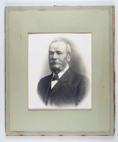
Photograph - Portrait of Councillor Long, Talma & Co
The district of Strathfieldsaye was proclaimed in 1861 and named a Shire on the 17th September in 1866. It remained a shire until amalgamation in 1994 when it became part of the City of Greater Bendigo. The shire was located 8 km to the south- east of Bendigo and covered an area of 601 square kilometres and extended from the Calder Highway to the Coliban and Campaspe Rivers. The shire's administration centre was in Strathfieldsaye until 1972 when new offices were opened in Kennington.Framed black and white head and shoulder portrait of Councillor Long. Profile to left with walrus moustache and mutton chops. Cut olive retangle mount. Verso; Long. On under board which has photograph attached; Talma & Co. / 119 Swanston St., / Melbournestrathfieldsaye shire council, councillor long -
 City of Greater Bendigo - Civic Collection
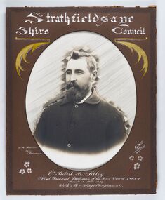
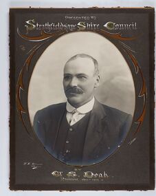
Photograph - Portrait of Councillor Doak, W H Robinson
The district of Strathfieldsaye was proclaimed in 1861 and named a Shire on the 17th September in 1866. It remained a shire until amalgamation in 1994 when it became part of the City of Greater Bendigo. The shire was located 8 km to the south- east of Bendigo and covered an area of 601 square kilometres and extended from the Calder Highway to the Coliban and Campaspe Rivers. The shire's administration centre was in Strathfieldsaye until 1972 when new offices were opened in Kennington.Framed black and white head and shoulder portrait of Councillor Doak with hand coloured and drawn detail. Left facing profile with walrus moustache. Cut oval brown mount decorated with text and scrolls. Hand written title top and lower centre.Presented to / Strathfieldsaye Shire Council / W. H. Robinson / Photo / JMB Gribble / by Cr S. Doak / President 1911 - 1912strathfieldsaye shire council, president of strathfieldsaye shire, councillor doak -
 City of Greater Bendigo - Civic Collection
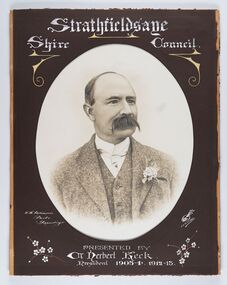
Photograph - Portrait of Councillor Keck, W H Robinson, c 1913
The district of Strathfieldsaye was proclaimed in 1861 and named a Shire on the 17th September in 1866. It remained a shire until amalgamation in 1994 when it became part of the City of Greater Bendigo. The shire was located 8 km to the south- east of Bendigo and covered an area of 601 square kilometres and extended from the Calder Highway to the Coliban and Campaspe Rivers. The shire's administration centre was in Strathfieldsaye until 1972 when new offices were opened in Kennington.Framed black and white head and shoulder portrait of Councillor Keck with hand coloured and drawn detail. Profile slightly to right with walrus moustache. Cut oval brown mount decorated with text and flowers. Hand written title top and lower centre.Strathfieldsaye / Shire Council / W.H. Robinson / Photo / Bendigo / J.H.E Gribbs / Presented by / Cr Herbert Keck / President 1903-4. 1912-13.shire of strathfieldsaye, councillor keck, strathfieldsaye shire council, president of strathfieldsaye shire -
 City of Greater Bendigo - Civic Collection
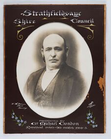
Photograph - Portrait of Councillor Michael Condon, W H Robinson
The district of Strathfieldsaye was proclaimed in 1861 and named a Shire on the 17th September in 1866. It remained a shire until amalgamation in 1994 when it became part of the City of Greater Bendigo. The shire was located 8 km to the south- east of Bendigo and covered an area of 601 square kilometres and extended from the Calder Highway to the Coliban and Campaspe Rivers. The shire's administration centre was in Strathfieldsaye until 1972 when new offices were opened in KenningtonFramed black and white head and shoulder portrait of Councillor Condon with hand coloured and drawn detail. Profile slightly to left. No facial hair. Cut oval brown mount decorated with text, scrolls and flowers. Hand written title top and lower centre.Strathfieldsaye / Shire / Council / W. H. Robinson / Photo / Bendigo / JMB Gribble / Presented by / Cr Michael Condon / President 1889 - 90. 1895-6. 1904 - 5strathfieldsaye shire council, president of strathfieldsaye shire, councillor condon -
 City of Greater Bendigo - Civic Collection
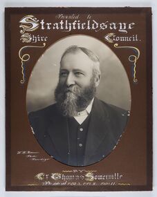
Photograph - Portrait of Councillor Thomas Somerville, W H Robinson
The district of Strathfieldsaye was proclaimed in 1861 and named a Shire on the 17th September in 1866. It remained a shire until amalgamation in 1994 when it became part of the City of Greater Bendigo. The shire was located 8 km to the south- east of Bendigo and covered an area of 601 square kilometres and extended from the Calder Highway to the Coliban and Campaspe Rivers. The shire's administration centre was in Strathfieldsaye until 1972 when new offices were opened in KenningtonFramed black and white head and shoulder portrait of Councillor Somerville with hand drawn detail. Profile slightly to left, face has full beard. Cut oval brown mount decorated with text and scrolls. Hand written title top and lower centre.Presented to / Strathfieldsaye / Shire Council / W. H. Robinson / Photo / Bendigo / by / Cr Thomas Somerville / President 1892 - 3. 1901.2. 1910.11 strathfieldsaye shire council, councillor somerville, president of strathfieldsaye shire -
 City of Greater Bendigo - Civic Collection
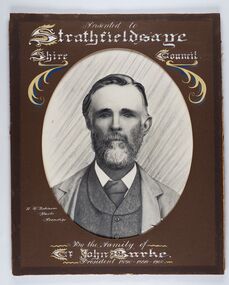
Photograph - Portrait of Councillor Burke
The district of Strathfieldsaye was proclaimed in 1861 and named a Shire on the 17th September in 1866. It remained a shire until amalgamation in 1994 when it became part of the City of Greater Bendigo. The shire was located 8 km to the south- east of Bendigo and covered an area of 601 square kilometres and extended from the Calder Highway to the Coliban and Campaspe Rivers. The shire's administration centre was in Strathfieldsaye until 1972 when new offices were opened in Kennington. Framed black and white head and shoulder portrait of Councillor Burke with hand coloured and drawn detail. Profile centre facing with beard. Cut oval brown mount decorated with text and fscrolls. Hand written title top and lower centre. Wooden frame with detail and gold inner.Presented to Strathfieldsaye / shire Council / w. H. robinson / Photo / Bendigo / By the family of / Cr John Burke / President 1890 - 1899 - 1900strathfieldsaye shire council, councillor burke, president of strathfieldsaye shire -
 City of Greater Bendigo - Civic Collection
Photograph - Councillor group portrait, W H Robinson, Strathfieldsaye Shire Council, 1909
The district of Strathfieldsaye was proclaimed in 1861 and named a Shire on the 17th September in 1866. It remained a shire until amalgamation in 1994 when it became part of the City of Greater Bendigo. The shire was located 8 km to the south- east of Bendigo and covered an area of 601 square kilometres and extended from the Calder Highway to the Coliban and Campaspe Rivers. The shire's administration centre was in Strathfieldsaye until 1972 when new offices were opened in Kennington.Photographic group portrait of eleven Strathfieldsaye Shire Councillors in front of the Strathfieldsaye Shire Hall. Five men are seated and six standing with one man standing further in back ground on the building's verandah. Photograph is attached directly to green mount card and framed. Gold lettering on mount.Strathfieldsaye Shire Councillors / R. B. Brennan (Sec.) W. J. Lowdes S. Doak M. Burns () N Condon B. Code (Inspector) / WH Robinson Photo Bendigo / T Somerville / W. I. Long / Fred Osborne (President) H Keck / W Dresler / With the President's (Cr. Fred Osborne) Compliments / September 23rd, 1909shire of strathfieldsaye, strathfieldsaye shire council, president of strathfieldsaye shire, strathfieldsaye shire hall -
 City of Greater Bendigo - Civic Collection
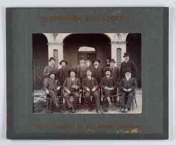
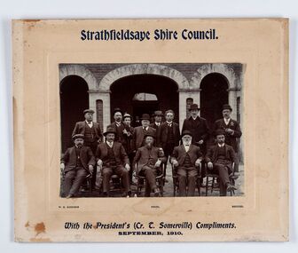
Photograph - Councillor group portrait, W H Robinson, Strathfieldsaye Shire Council
The district of Strathfieldsaye was proclaimed in 1861 and named a Shire on the 17th September in 1866. It remained a shire until amalgamation in 1994 when it became part of the City of Greater Bendigo. The shire was located 8 km to the south- east of Bendigo and covered an area of 601 square kilometres and extended from the Calder Highway to the Coliban and Campaspe Rivers. The shire's administration centre was in Strathfieldsaye until 1972 when new offices were opened in Kennington. Group portrait of 13 men / councilors, 5 seated and 8 standing dressed in suits. There are another 2 men further back in front of the hall doors. Photograph is taken outside the Strathfieldsaye Shire Hall.Srathfieldsaye Shire Council. / With the President's (Cr T. Somerville) Compliments. / September, 1910 / W.H. Robinson Photo. Bendigo Verso; William Drechslershire of strathfieldsaye, president of strathfieldsaye shire, strathfieldsaye shire council -
 City of Greater Bendigo - Civic Collection
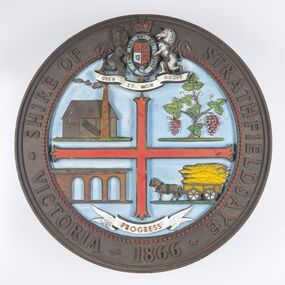
Sign - Shire of Strathfieldsaye Coat of Arms
The district of Strathfieldsaye was proclaimed in 1861 and named a Shire on the 17th September in 1866. It remained a shire until amalgamation in 1994 when it became part of the City of Greater Bendigo. The shire was located 8 km to the south- east of Bendigo and covered an area of 601 square kilometres and extended from the Calder Highway to the Coliban and Campaspe Rivers. The shire's administration centre was in Strathfieldsaye until 1972 when new offices were opened in Kennington. This coat of arms was commissioned for the front of the shire hall building.Brass painted coat of arms or emblem within a circle of the Shire of Strathfieldsaye. Outer rim contains text: SHIRE OF STRATHFIELDSAYE VICTORIA 1866 with the shield of the monarch of the United Kingdom centre top. The shield is divided into four parts with images reflecting the leading industries of the time; wine growing, mining, farming and tanning. The motto PROGRESS is depicted lower centre of shield. SHIRE OF STRATHFIELDSAYE / VICTORIA / 1866 / PROGRESSshire of strathfieldsaye, city of greater bendigo amalgamation, city of greater bendigo signs -
 City of Greater Bendigo - Civic Collection
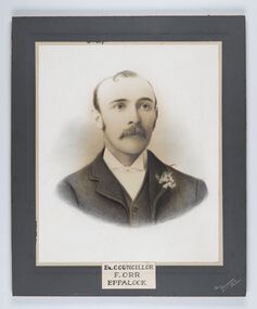
Photograph - Portrait of Councillor Orr, The Yeoman Studios, Ex. Councillor / F. Orr / Eppalock
The district of Strathfieldsaye was proclaimed in 1861 and named a Shire on the 17th September in 1866. It remained a shire until amalgamation in 1994 when it became part of the City of Greater Bendigo. The shire was located 8 km to the south- east of Bendigo and covered an area of 601 square kilometres and extended from the Calder Highway to the Coliban and Campaspe Rivers. The shire's administration centre was in Strathfieldsaye until 1972 when new offices were opened in Kennington. Eppalock Ward is one of three wards in the Greater Bendigo municipality which includes the former Strathfieldsaye Shire. Framed black and white head and shoulder portrait with hand coloured detail. Man with profile slightly to right, walrus moustache, image encircled. Photograph is attached to mount card. Hand written title lower centre.Ex. Councillor / F. Orr / Eppalock / The / Yeoman / Studiosshire of strathfieldsaye, councillor orr -
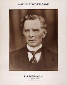 City of Greater Bendigo - Civic Collection
Photograph - Portrait of Shire Secretary Brennan, Unknown
The district of Strathfieldsaye was proclaimed in 1861 and named a Shire on the 17th September in 1866. It remained a shire until amalgamation in 1994 when it became part of the City of Greater Bendigo. The Shire was located 8 km to the south- east of Bendigo and covered an area of 601 square kilometres and extended from the Calder Highway to the Coliban and Campaspe Rivers. The shire's administration centre was in Strathfieldsaye until 1972 when new offices were opened in Kennington. Secretary Brennan, son of Councillor M. Brennan was appointed after his fathers death to the role and according to the The Bendigo Independent was in the role in 1917. See References.Framed black and white head and shoulder portrait of Councillor Brennan. Profile slightly to left. Cut rectangle cream mount. Hand written title top and lower centre. Shire of Strathfieldsaye / R. B. Brennan, Esq / Secretarystrathfieldsaye shire council, secretary strathfieldsaye shire -
 Orbost & District Historical Society
framed certificate, 1917
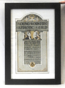
The Young Workers' Patriotic Guild was formed in Victorian schools in 1916. Each child who raised one pound 'by personal productive effort' received a certificate. The money was used for the war effort. This certificate was presented to Eileen McDougall, a pupil of Lochend School, in 1917 in recognition of becoming a member of the Young Workers' Patriotic Guild.This item reflects the war efforts of Victorian children during WW1.A coloured certificate framed in dark plain wooden frame. The certificate is from the Young Workers' Patriotic Guild, and includes mythical representations of 'Justice' and 'Peace' at the top, together with a female face wearing a laurel wreath. Below the banner headline are two young girls, one shown knitting a black and red sock, and the second holding what appears to be a hammer and a block of wood. The certificate commemorates the work done by a pupil at a Victorian school as a member of the Guild. It is dated 1917, and signed by the Minister of Education, the Director of Education, and the Headmaster of Kennington school. The name of the designer appears at the bottom of the certificate; it appears to be Harold Herbert. Laurel leaves and berries, and the initials 'EVD' [Education Department Victoria] appear at the base of the certificate. (from Museum Victoria)mcdougall-eileen ww1 certificate-young-workers'-patriotic-guild education fundraising -
 City of Greater Bendigo - Civic Collection
Photograph - Portrait of Councillor Brennan, W H Robinson
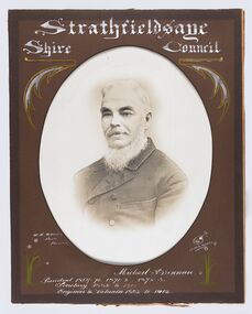
The district of Strathfieldsaye was proclaimed in 1861 and named a Shire on the 17th September in 1866. It remained a shire until amalgamation in 1994 when it became part of the City of Greater Bendigo. The shire was located 8 km to the south- east of Bendigo and covered an area of 601 square kilometres and extended from the Calder Highway to the Coliban and Campaspe Rivers. The shire's administration centre was in Strathfieldsaye until 1972 when new offices were opened in Kennington. Councillor Michael Brennan held roles of Shire Secretary and Clark of Works until around 1998 when his son R. B. Brennan was appointed Assistant Secretary and then Shire Secretary to assist his father with the work load during his later years. Michael Brennan remained Clerk of Works until his death at which time his son was appointed to the duties previously held by his father. Framed black and white head and shoulder portrait of Councillor Brennan with hand coloured and drawn detail. Profile to left. Cut oval brown mount decorated with text and flowers. Hand written title top and lower centreStrathfieldsaye / Shire Council / W H Robinson / Photo / Bendigo / J H B Gribble / Michael Brennan / President 1869 - 70. 1871 - 2. 1872 - 3 / Secretary 1882 to 1900 / Engineer & Valuator 1882 to 1902strathfieldsaye shire council, councillor brennan, president of strathfieldsaye shire -
 City of Greater Bendigo - Civic Collection
Medal, Stokes and Son, Eaglehawk Football Club, 1925
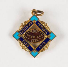
Established in 1880, the Eaglehawk Football Club was one of the first teams to join the Bendigo Football League and to date the senior team has won twenty eight premierships, the most of any team in the league. The Eaglehawk colours are represented by two blues, the light blue of Oxford University and dark blue of Cambridge University which is represented on this pin in the coloured enamel. This pin issued in 1925 commemorates Eaglehawk Football Club's 1924 win which was played at Kennington Oval against Rochester. Final scores were 14.17.101 to 8.9.57. The Bendigo Football League formally known as the Sandhurst Football Association was formed in 1881 and over the decades has grown to include some of the longest established teams in Australia including Castlemaine (formed 1859 - joined 1925) and Kyenton (formed1875 - joined 1947). The local municipal councils worked with the League to provide playing fields for the competition and the Upper Reserve now known as the Queen Elizabeth Oval continues to host many League games. In 1928 at the annual dinner it was noted by the Bendigo Football League that the 'grounds were not all that could be desired, but that they were getting along well with the councils'. Mayor Batchelder responded saying that the council realised that 'the League was a major tenant and was out to do its best for them'. (1) (FN The Riverine Herald, Fri 19 Oct 1928 Page 1). The City of Greater Bendigo continues to work with the various leagues to provide playing fields for competitions as well as supporting the emerging of football and netball clubs and the introduction of women's football teams which has seen great changes to traditionally male dominated football clubs. Diamond shaped commemorative medal with circular scroll. Football sits inside inner diamond shape. front; Eaglehawk Football Cub 1925 / Premiers / 1924 verso; Stokes & Sons / Melbbendigo football league, city of greater bendigo community groups, borough of eaglehawk, making a nation exhibition, city of greater bendigo sport -
 Glen Eira Historical Society
Document - Laundries
... 'Kennington' ...Newspaper cutting of workers at the Economy Laundry in Elsternwick, 1938, source unknown, taken by Harold Paynting. Typed recollections by Felicity Campbell dated 02/04/2007 and further research by Claire Barton from SANDS AND MCDOUGAL’S 1942 edition, dated 02/07/2013, noting other boundaries in Caulfield municipality.elsternwick, economy laundry, point nepean road, presbyterian church, orphanages, regent lodge, st john’s presbyterian church, glen huntly road, foster street, campbell family, bristol, carnegie, collis m mrs, glen eira road, cutland e mrs, 'kennington', riddell parade, 'kooyong', 'primrose', martin street, wadekin a mrs, murrumbeena road, murrumbeena, 'waverly', hawthorn road, caulfield north, paynting harold, rosstown road, gardenvale road, glen eira road, caulfield, elsternwick girls' home, regent street, presbyterian womens mission union, recipe books -
Glen Eira Historical Society
Ephemera - St. Mary’s Church, Caulfield
Two copies from St. Mary’s Anglican Church Caulfield, orders of service to celebrate Victoria’s 150th anniversary April 28, 1985. Four copies of pamphlet from St. Mary’s Anglican Church, Caulfield for The Joys of Living in Victoria, a festival of flowers and music dated April 25-28 1985. Included is a brief history from the 1850’s to 1985 of the church. Official opening leaflet with details of events and sponsors. The Joys of Living in Victoria, a festival of flowers and music order of service. Roneoed copy dated 25/04/1985.st. mary’s anglican church, caulfield, brooks r.c. rev., glasson william, organists, glen eira road, allen s. m. and sons, furniture stores, kennington laundry and drycleaners, drycleaners, glen huntly road, elsternwick, nepean highway, gardenvale, caulfield south, t. bathursts and co., funeral directors, ricks camera shop, elsternwick furnishing co., rothels pty. ltd., the sausage factory, four corners picture framing co., taylors the discount store, eight st. georges road, reception rooms, mane event hairdressing, fiskens pharmacy, boyd w. fox chemist, elsternwick travel world, mahony denis, hairline 309, hairdressers, madge tulloch florist, florist shops, michelson and associates, estate agents, port phillips press pty. ltd., printing industry, sommers jill, caulfield city choir, choirs, the tait-smith chamber group, tudor choristers, cathedral brass ensemble, trumble joan, brookes raymond rev., porter miss, park street, stephen george sir, hood crescent, bluestone, reid mr., architects, macartney mrs., st. mary’s church, st. stephen’s, gardenvale, st. clement, elsternwick, st. agnes, glenhuntly, glen huntly, st. catherine, caulfield, langley canon, shelford, green bishop, schools, helenslea, caulfield grammar school, davis j.h. rev., house names